Data Packs NZ Data Index
NZ Data Index Labs
An index of public NZ Esri REST services. Searchable, mappable and queryable.
Users and agents search and query the Esri REST services councils and agencies already publish, and get answers with a citation.
Data types available
Vector data only, published as Esri REST endpoints by territorial, unitary and regional authorities and by Crown agencies.
- Points Addresses, assets, monitoring sites
- Lines Roads, pipes, streams
- Polygons Parcels, zones, hazard extents
Current coverage
- 63
- servers
- 23,442
- layers and tables
- 449 million
- features
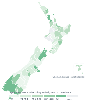
Shading is layers per territorial or unitary authority. Indexed in 61 of 67 territorial and unitary authorities. Figures as at 8 September 2026.